Event location at OMIV sites is difficult because most recorded signals lack of impulsive waves, so that a satisfying time picking of first arrivals is difficult even for large amplitude signals. Another difficulty is to distinguish P from S waves, because of the small distances between the source and the sensors, and because of the lack of high frequency waves. Precise 3D seismic velocity models exist for few sites, but generally a uniform velocity is used. In order to account for variations of seismic wave velocities, calibration shots are performed in order to estimate a time correction for each seismometer. This allows reducing the location error to about 50 m for events located inside the seismic network.
Two localisation strategies are used currently at OMIV sites depending on the density of the seismic network:
- For landslides with dense seismic network (e.g. Séchilienne), cross-correlation or beam-forming methods, of signals recorded at different sensors are implemented to precisely measure the time delays between sensors;
- For landslides with sparse seismic network (e.g. Super-Sauze, La Clapière), beam-forming approach are performing poorly due to the loss of coherence of signals waveforms caused propagation effects. An approach combining precise onset picking using a kurtosis-based method with an iterative cross-correlation re-picking has been designed (APOLoc) to assess onset-time delays for a given event.
Grid search methods are then used to infer the position of the source from the onset-time delays measured at each station. Event location is performed routinely for each seismic network and is used to better discriminate seismic signals. For instance, distant earthquakes can be recognized by their high apparent velocity, due to their large dip angle. Rockfalls can be identified by their azimuth evolving during their propagation which is consistent with a source moving downslope.
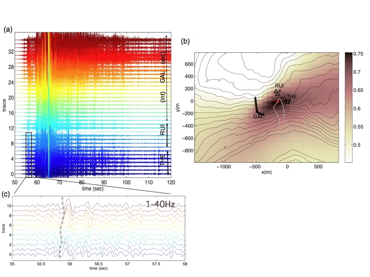 |
| Application of beam-forming method at Séchilienne landslides: (a) waveforms of a rockfall signals detected by all channels, (b) map of average correlation and estimated source location (red circle) and (c) zoom of the first seconds of the signal for a few channels. |
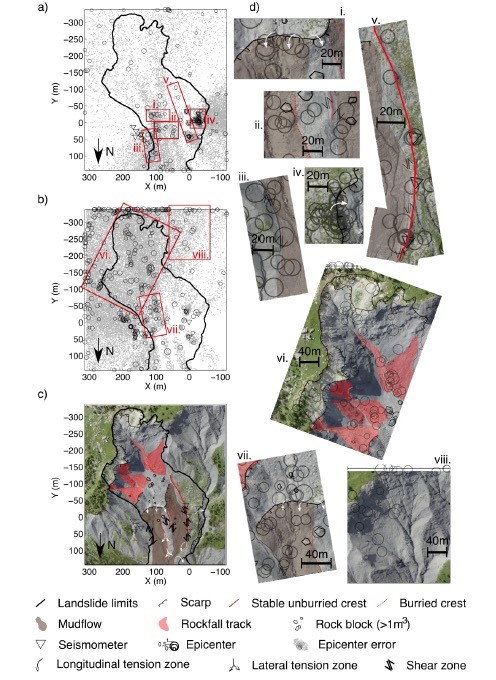 |
| Application of APOLoc method at Super-Sauze landslide: Location of the endogenous seismicity (a) micro-quakes, (b) rockfall; (c) map of the geomorphological structures and (d) zoom on the location of some seismic clusters in relation with the geomorphological structures of the landslide. |