 |
 |
The OMIV GPS Service proposes a near-real time characterization of the surface displacements using permanent GPS stations installed at different locations on the monitored landslides. The landslides show very different displacement rates (ranging from a few centimetres to several meters per year) and different kinematic regimes (e.g. continuous displacement at a nearly constant velocity or succession of periods of acceleration/deceleration).
The Service consists in acquiring continuous GPS observations, transfering the data, controlling the quality of the observations, and proposing a daily calculation of the position (baseline, coordinate) with a millimetric accuracy using a specific processing.
Field installation
A similar monitoring strategy has been set up for all landslides and consists in the installation of 2 or 3 GPS receivers within the landslide (e.g. ‘moving GPS’), and 1 GPS receiver outside the landslide boundaries in stable areas (e.g. ‘base GPS’). The GPS data are acquired with TRIMBLE NetRS or TRIMBLE R9 geodetic dual-frequency receivers equipped with TRM41249.00 antenna and a TZGD radome. Every day, one 30-second daily file (i.e. 2880 sessions) and 24 1-second hourly files (i.e. 3600 sessions) are produced. The data are stored locally and, within one day, a wireless access point allows the data transmission to a local database server (located at EOST) and the processing.
Data processing
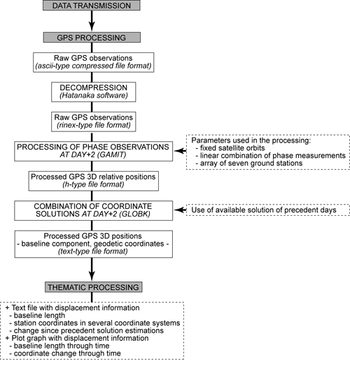
The processing is performed with the GAMIT/GLOBK package dedicated to the estimation of three-dimensional relative positions of ground stations and satellite orbits. An automated script has been developed to obtain the positions of each station. The script is activated daily and integrates automatically the most recent available GPS data to calculate the baseline and position time series. The geodetic coordinates (latitude, longitude and ellipsoid height) and the baseline lengths are extracted from the output file of GLOBK. The geodetic coordinates are then converted to local geographical coordinate systems (Lambert zone; North, East and altitude) with the Circé, software developed by the French Topographic Survey IGN (Institut Géographique National). The methodology is detailed in Malet et al. (2011), and the flowchart is presented below.
Emails with the latest GPS solutions are send daily to the scientific coordinator of each landslides and to stakeholders in charge of the risk management.
The data available online are:
- raw GPS observations in Rinex-file format
- GPS solutions (baseline lengths, station coordinates) in Ascii text-file format
- GPS solutions (baseline lengths, station coordinates) in graphics
 |
 |
|
Example of the geodetic monuments used for the GPS receivers at the La Valette landslide. The top of the figure presents the base station LVAL, and geometry of the geodetic monument; the bottom of the figure presents the moving station lva1, and the geodetic monument. |
Automated processing of the GPS data
|